LMSL Project
Location
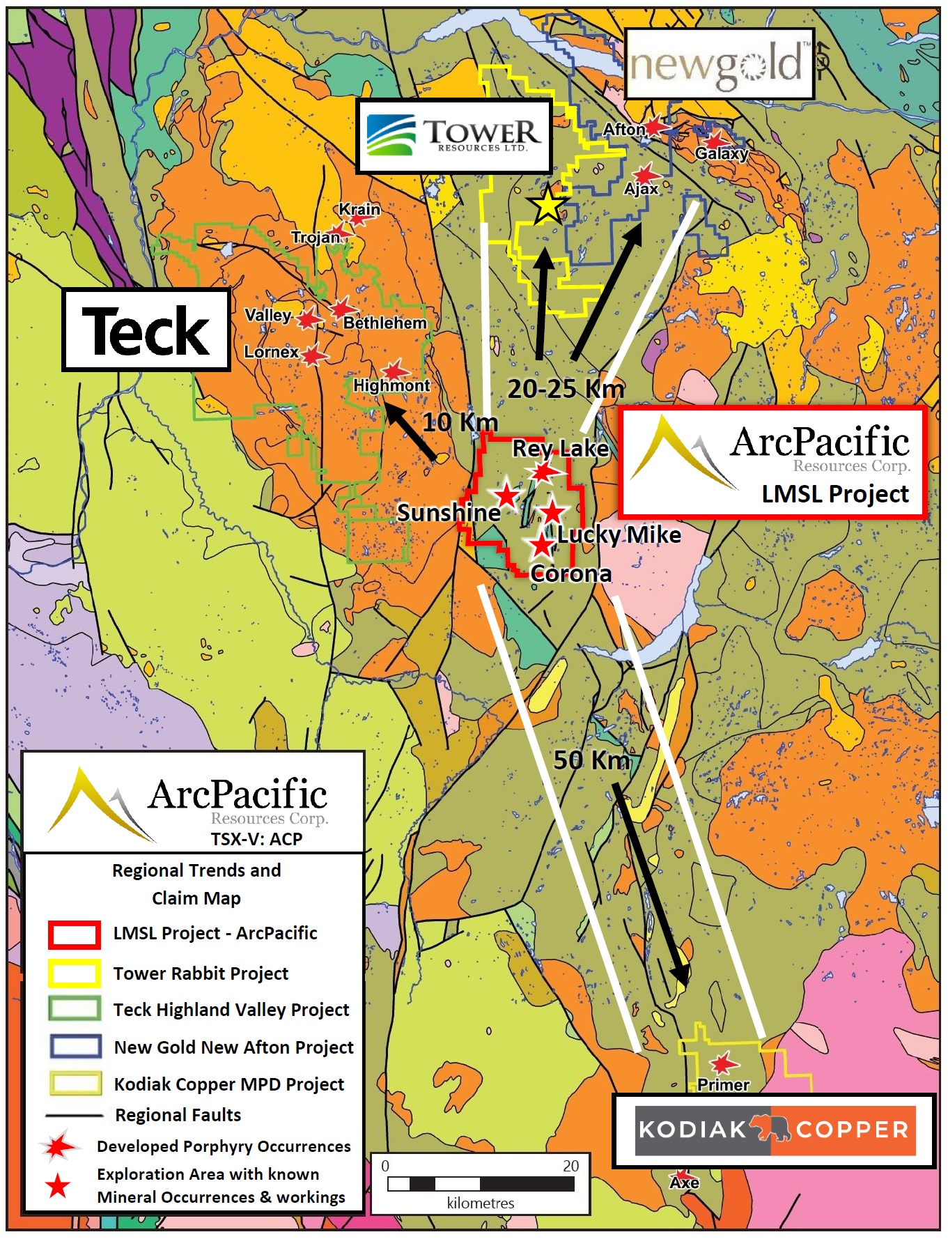
- Located 20km north of Merritt, British Columbia, Canada, in the Nicola Mining Division.
Size
- Growing project size totaling over 11,840 hectares
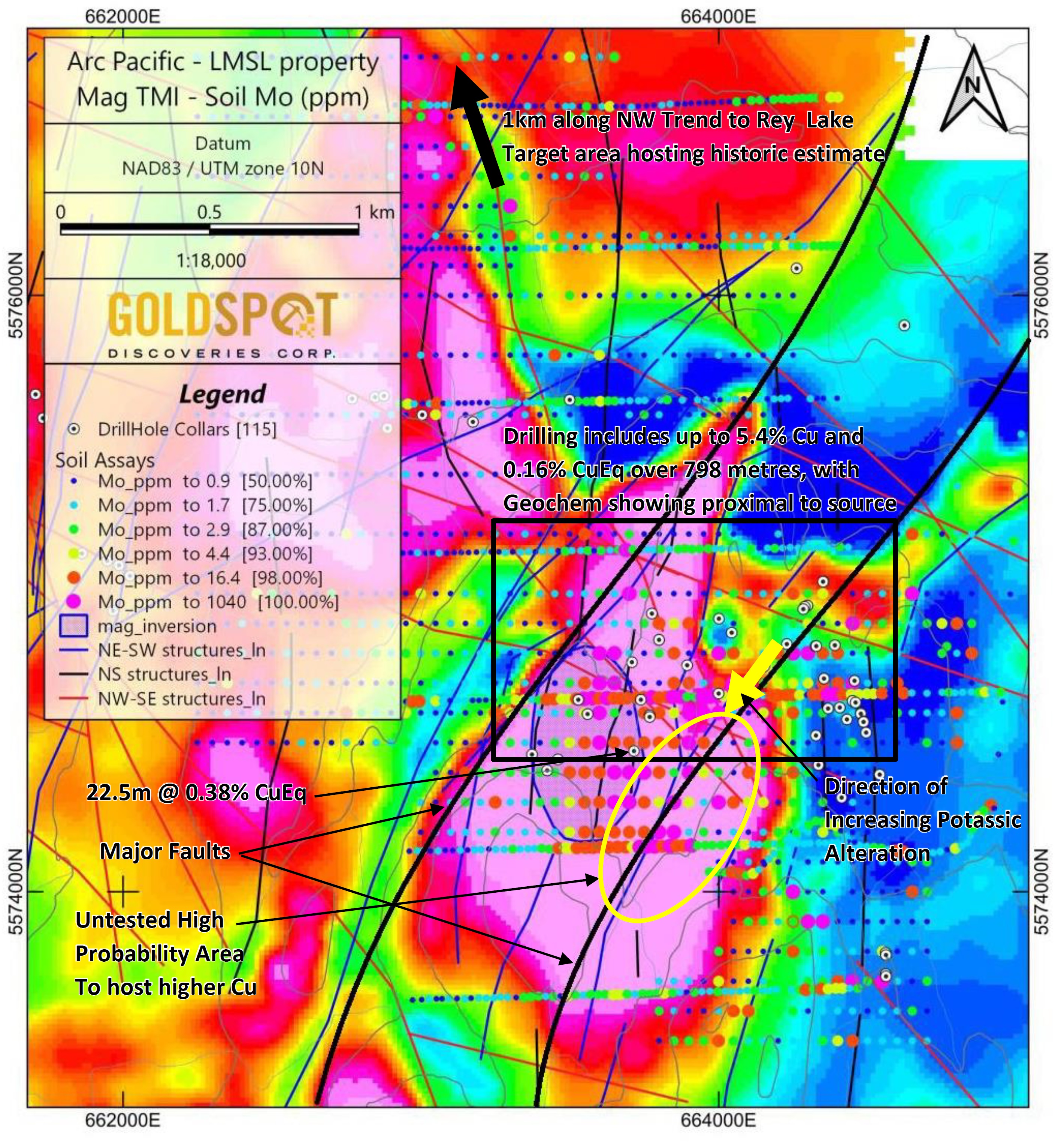
- New Rey Lake addition adds known copper porphyry system to the property.
- Historic estimate of 74 million tonnes @ 0.23% CuEq.
- Potential to expand historic grades and tonnages through additional drilling.
- Extensive skarn zones with high grade silver samples running in excess of 2,000g/t Ag.
- Historic skarn mines indicate the main mineralizing system remains to be found.
Acquisition
- LMSL Owned 100%
- Rey Lake addition, Option to earn 100%
Target
- Copper-gold-silver-molly porphyry system.
- Peripheral silver-lead-zinc mineralized polymetallic veins
Infrastructure
- Well developed network of logging roads accessing property, proximal to power and water and local labor force.
Proximal Key Projects
- Highland Valley, Teck Resources – Largest Copper mine in Canada
- MPD Project - Kodiak Copper - new copper-gold porphyry discovery
- New Afton, New Gold Inc. - high grade copper - gold alkalic porphyry deposit.
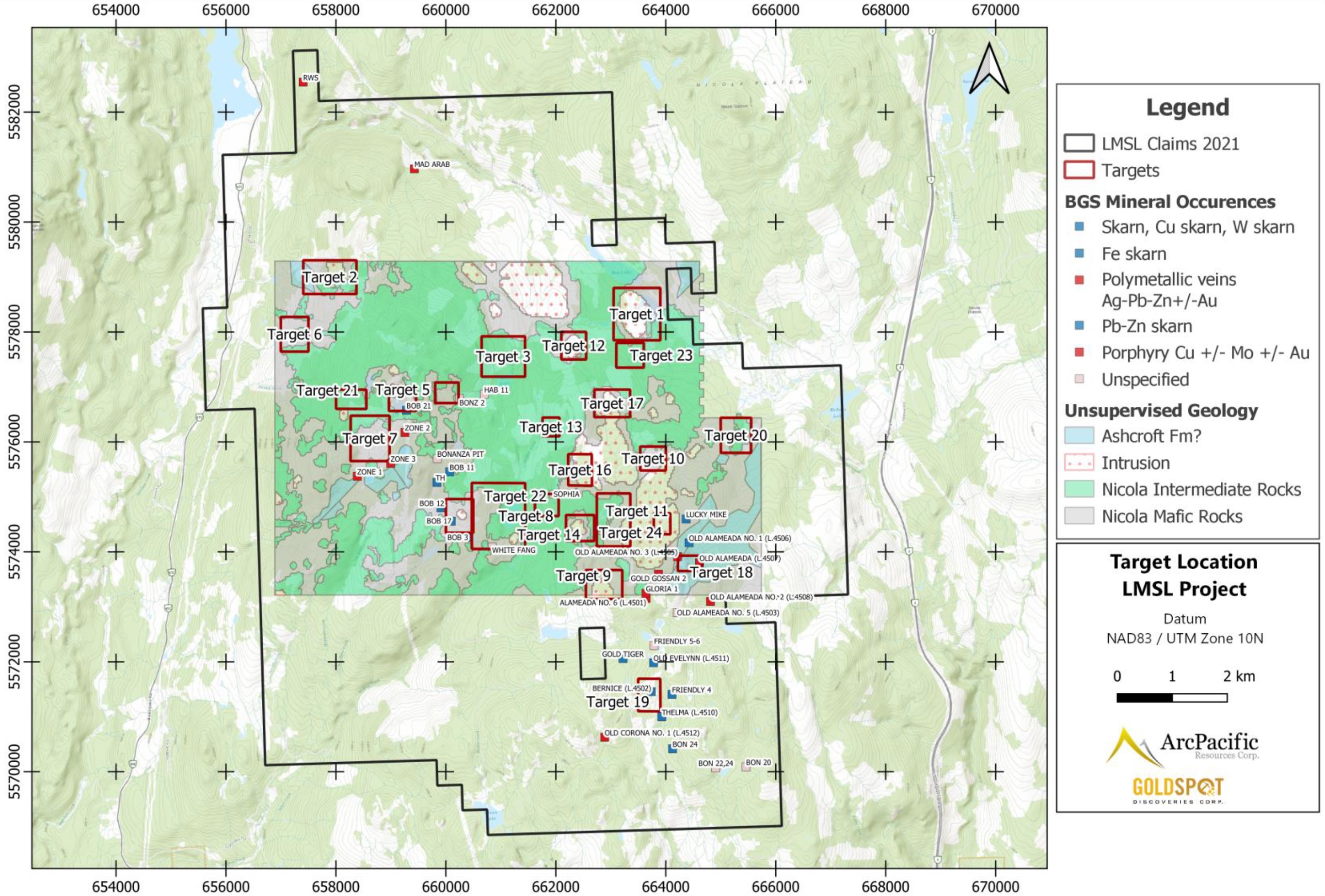
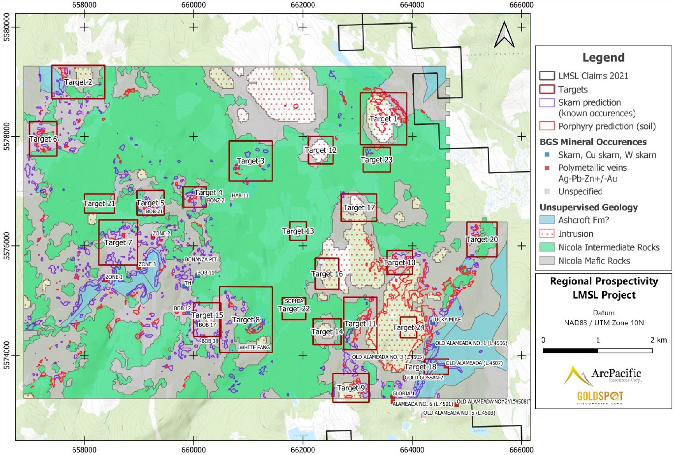
Project Maps
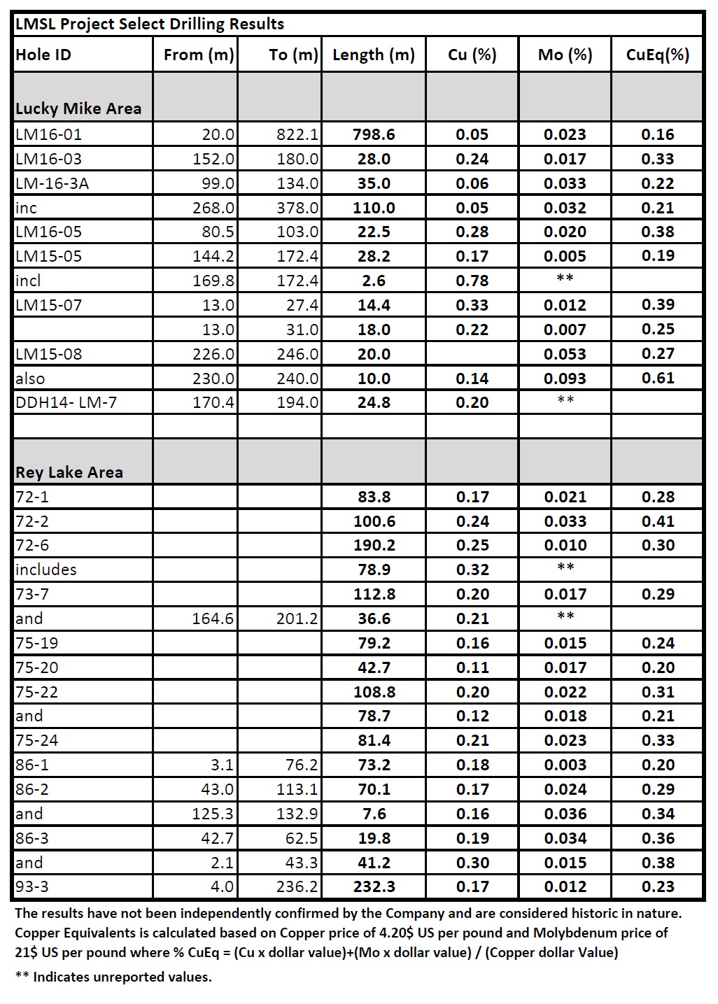
Select Historic Drilling Results
History
- First exploration on Rey Lake area was recorded in 1972 by Asarco, who completed extensive exploration program including mapping, geophysics, soil geochemical surveying, road building, trenching 982 metres of diamond drilling and 3,013 metres of percussion drilling.
- Additional exploraiton on the Rey Lake area was conducted into the early 1990's with no significant work completed after this.
- Initial development on high-grade skarn mineralization was recorded in 1925 which included open cuts, adits and shafts.
- One of several historic mines on the property was in operation until a fire destroyed the head frame and buildings in 1930 after which the claims were sold in a court order.
- Work in 2014 through 2016 began to explore the Lucky Mike area with positive rsults showing well developed hyrothermal alteration and mineralization. The results of this work indicate that there is potential to identify further porphyry style mineralization nearby.
Mineralization
- Copper porhyry style mienraliazation including skarn zones and breccia pipes are known to occur on the project.
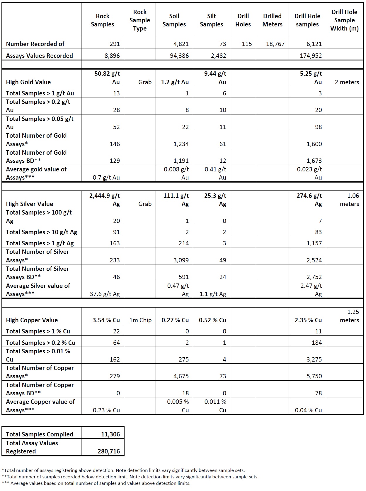
- Gold mineralization up to 50.82 g/t has been sampled on the property and is related to copper mineralization.
- Silver production with ore shipments averaging 2,000g/t Ag has been recorded from historic high grade skarn zones on the property.
- Multiple zones of polymetallic veining and skarn peripheral to copper porphyry style mineralization.
- Breccia pipes and mineralized porphyritic intrusions are also known to occur.
Copper Gold and Silver Results Statistics Table
Ongoing Exploration
Phase 1
- COMPLETE - developed extensive new digital database from all recorded historic work on the project including:
- 75 assessment reports
- Soils: 4860 Samples; Rocks: 291 Samples; Silts: 76 Samples
- Drill Holes: 107 totalling 17,989 meters
- Drill Samples: 5,700
Phase 2
- COMPLETED - GoldSpot Discoveries generated 24 prioritized targets for ongoing exploration utilizing Avante's extensive digitized database.
Phase 3
- Upcoming work following recommendations proposed by GoldSpot to assess 24 prioritized targets.
- Complete geophysical surveys to extend existing zones of mineralization within the Lucky Mike Area and the Rey Lake area in order to prioritize drilling targets.
- Planned drilling program.
Disclosure
The historical estimates reported above were based on eight diamond drill holes and nine percussion holes completed between 1972 and 1973 by Asarco (American Smelting and Refining Company). A copper value was set at $0.75 per pound and molybdenum at $1.85 per pound for the estimate. Further drilling would be required to verify the estimate as current. A qualified person has not done sufficient work to classify the historical estimate as current mineral resources or mineral reserves and the issuer is not treating the historical estimate as current mineral resources or mineral reserves.
The Qualified Person (“QP”) for the Company has not verified the historical sample analytical data disclosed on this page. While the Company has obtained all historic records including analytical data from the previous owners of the Property and from various government databases, the Company has not independently verified the results of the historic sampling.
Adrian Smith, P.Geo., is a QP as defined by National Instrument 43-101 for the above-mentioned project. The QP is a member in good standing of the Engineers and Geoscientists of British Columbia (EGBC) and is a registered Professional Geoscientist (P.Geo.). Mr. Smith has reviewed and approved the technical information disclosed above.